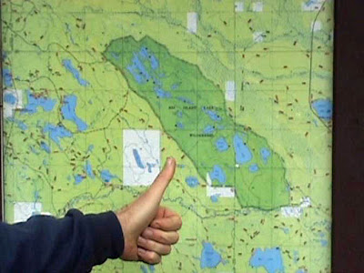
The Big Island Lake Wilderness Area is located southeast of Munising, MI, in the Hiawatha National Forest. To get there from Munising, go east on M-28 to Forest Hwy 13, almost opposite the Post Office in Wetmore (there is a BP gas station on the southeast corner which is good for last minute supplies). Turn south, and go about 8.7 miles to Forest Rt 2254 (aka Co. Rd 445 and Kentucky Trail) and turn right/east. This is a seasonal road, and has the easiest access points into the Wilderness Area.

Continue SE about 4 miles from Forest Hwy 13 to the parking area for the main trail into Big Island Lake--it will be on your left. Use caution, the road is narrow and turning, and there is more traffic on it than you might think. You will have crossed the Little Indian River on Kentucky Trail, this is near the northern edge of the Wilderness Area.

The main access point is at Big Island Lake about a half-mile further, and this is the shortest carry in. The parking area does fill up, so get there early. Walk-in is less than a 1/4-mile over easy terrain.

The next trail head, about a mile south, is on the left (marked by boulders and a brown signpost, and goes into Coattail Lake. There is a campsite with a fire ring at the edge of the lake. An easy walk in, but about 3/4-mile in. Recently there has been a lot of beaver activity near the campsite.
About 3/4 mile south of that is the trail into Ned's Lake. This is not quite as visible, but there is a trail which comes in on the right about opposite the walk-in. Turn right--there is a parking area just the other side of the trees.
About another 3/4 mile south of this is the trail with goes into Vance, Twilight and Byers Lakes.

The walk-in is about a mile, but most is pretty level and easy going. Quite a few trees have gone down that you have to go around, but not too bad. The trail branches just before Twilight Lake, about 3/4 mile in. Go south to Twilight, follow to the north to go to Vance Lake. Just before you get to Vance, the trail is more faint on your right which goes over to Byers Lake. There has also been a lot of beaver activity in this general area. Byers Lake level is up several feet, and the beam which was walkable across the outlet of Vance is now a beaver dam with flowage making it dubious footing to get up to Klondike Lake. Not a bad spot to put in with a canoe or kayak though.
To get in during the winter, or from Manistique. Take 94 north about 22 miles to Thunder Lake Rd. go left, through Steuben. About 1 1/2 miles after pavement ends, Kentucky Trail comes in on the right. The access to Twilight Lake is marked by boulders about two miles up the road on the right.

Hope this helps with your trip. (We recommend getting a Big Island Lake Wilderness Area map, available at the Hiawatha National Forest Munising Ranger District office in Munising.) For us, we just take a walk, we live here! We are the private holding shown in white on Farm (aka Blush Lake) at the southwest corner of the Wilderness Area that is shown in dark green.

From 8109 (the Haywire) you can canoe up Delias Run but you will need to cross three beaver dams. On the portage from Vance to Klondike there is a very muddy section (always) about 40 feet. Klondike is a beautiful lake with only one campsite. Well worth the effort no matter how you get there!
ReplyDelete