Blush Lake, Big Island Lake Wilderness Area, MI

Blush Lake, Big Island Lake Wilderness Area, MI

Saturday, January 29, 2011

Snowmobiling in Michigan's Upper Peninsula


Snowmobile Our home at Blush Lake, while in the Big Island Lake Wilderness Area, is near the center of prime snowmobiling country. All Forest roads are open to snowmobiling unless otherwise posted. Actually, the Hiawatha National Forest has over 3,000 miles of roads and trails open to snowmobiling. Regulations and Snowmobile Trail Maps are available online and at the District Offices of the Hiawatha National Forest.

The Munising District of the Hiawatha National Forest maintains a trail network totalling 55 miles of groomed trails. The Manistique District of the Forest maintains a network of 35 miles. These trails connect, and also connect with other trails making it possible to pretty much go anywhere in the U.P. by snowmobile! At this posting, we have about 30" of snow on the ground and the trails are good!

Kentucky TrailKentucky Trail (Co. Rd. 445), runs NW along the west Big Island Lake Wilderness boundary from Thunder Lake Rd and crosses Forest Hwy. 13 about 8 miles south of Wetmore. At our driveway, about 1 1/2 miles north of Thunder Lake Rd., the road ceases to be plowed, and Kentucky Trail becomes a wide, clear snowmobile trail for another 7 miles or so. Turning north along Forest Hwy. 13 you can hit the Coalwood Grade, part of the Munising Ranger District trail network.


From Forest Hwy. 13 going South on Kentucky Trail, turning East on Thunder Lake Rd. will take you through Steuben, MI and to the Haywire Grade. This groomed trail travels North and South. South will take you toward Manistique, and will tie into other trails which will take you west toward Nahma, and from there on toward Escanaba. The Lots of good motels and cabins are available in Manistique, Munising and in the Hiawatha Forest. It is a tough choice where to go, but not a tough choice to come!






Friday, January 21, 2011

Wolves in the Big Island Lake Wilderness Area, MI

Wolf, Big Island Lake Wilderness Area, MI


The Big Island Lake Wilderness Area is traversed by a pack of gray wolves. Visiting the area you may see their tracks, which are LARGE 3.5-4" across. ( Coyotes are also in the area, but they are much smaller, leaving tracks about 2.5" X 2.5" .) When you see a wolf track you won't mistake it for anything else--you will say " WOW, look at the size of that"!


It will be a very rare occurrence if you actually see a wolf, they are very shy. Last summer I walked in to Coattail Lake from Co. Rd. 445. There has been much beaver activity in the area of the designated campsite, and I was looking for beaver at the lakeside, when I looked down and saw the wolf tracks. Lots of them. I figured they were looking for beaver too.


It had rained hard the previous night, and the rain had just stopped as I set out. While I know that they have rarely been documented to bother humans, being alone there with a pack of wolves hunting nearby seemed pretty stupid, so I beat it back to the road. No problems with the wolves, just my nerves.


We live on the west side of Blush Lake, more or less in the south end of the wilderness area. Not infrequently at night we can hear coyotes howl, and less often but most certainly we can hear the wolves howl. You will know the sound when you hear it, deep and loud. Not yipping or yodelling like the coyote or fox. Once we heard coyotes howling, then wolves responding in the distance. The coyotes stopped calling at once. Wolves will defend their territory from coyotes, as well as dogs.


Local bear hunters will not take their dogs into the wilderness area, because they have had dogs attacked by the wolves. We have had no problems with our dogs, but they are house dogs, and do not run at large. Actually, we have had bear dogs come up onto our deck, but never wolves. To play it safe, I would recommend that if you plan to camp in the wilderness area, don't bring your pets along.
Wolf, Big Island Lake Wilderness Area


We have seen wolf tracks in the snow on the north end of our property and twice have seen wolves on the ice of Blush Lake. They moved along the north and west shores, and once we saw two cut across the far bay on the ice. I managed to clip these photos from a video I shot.

Thursday, January 13, 2011

Pike Spawning, Big Island Lake Wilderness Area

Pike Spawning, Blush Lake, Big Island Lake Wilderness Area, MI
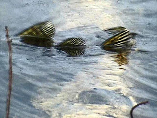
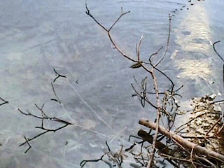
I was going through some photos and found these taken a year or so back. I happened to be down along the edge of Blush Lake with a camera, and heard splashing. It was very early in the spring, and the ice was still partially on the lake. The splashing came and went, at first I thought it was the otters, but as I got closer I could see fins.
Pike Spawning, Blush Lake, Big Island Lake Wilderness Area

I tried to be still along the shore as they swam my way. What a surprise! I saw three good sized pike mating along the logs and brush. The birch tree in the water that they swam across is large, maybe 14" across, just to give some scale.
Large Pike, Blush Lake

I knew the lake had perch and some bluegill, but these were a something to see. There is an outlet across the lake which winds through some marshy ponds, called the "Neville Lakes", and then becomes Camp 83--which feeds down into the Indian River. It doesn't seem likely, because in some areas it is so shallow and partially blocked, but perhaps they swam in from the creek?

Tuesday, January 4, 2011

Indian River Canoe Trail

Indian River Sign
Our home is about 1 1/2 miles north of the Indian River. For us, the easiest is at the bend where Thunder Lake Road changes from an east-west road along the north bank, and heads south, crossing the river. On the west side of the road is a launch area (across the river is a trail head for the Pine Marten Trail). The Indian River is designated a "Wild and Scenic River" which should secure a future for its waters and the wildlife that inhabit its environs. It has its headwaters near Hovey Lake west of Forest Hwy 13, about 10 miles south of Munising and it flows all the way into Lake Michigan, over 60 miles to the south.
Indian River from bridge Thunder Lake Rd

The river is usually not too wide, only about 30' in width, and in many areas it has very steep banks. It flows swiftly along through hardwood and coniferous forests, as well as marshy stretches. It is cold and has a strong current--trout can be found in the right areas.
Meander,Indian River, from high bank


A series of good access points allow for plenty of paddling options for those who don't wish to do the full route. Downed trees do present hazards, and in the spring the flow can be very strong. Check on conditions in the area before you decide where to put in and take out.

The Bear Tree

Bear claw marks, Big Island Lake Wilderness Area MI
When the leaves are off the trees, we can see many things we don't even know are there in the summer. For instance the steep ridges occur along many of the lakes, or the increased visibility of the rivers from the trails. It makes the woods seem almost a different place.


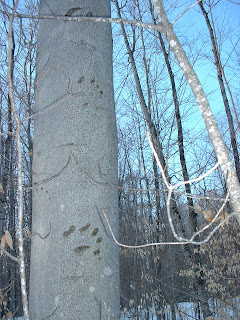
Walking through the woods, we found this tree marked with the claw marks of a bear who had climbed it. It is a beech tree, and the smooth gray bark is easily scarred, leaving a very clear record. Black bear are plentiful in the area, although we have never seen one near our home. We are careful to pull in the bird feeders in early spring when the bear come out from hibernation, and never leave any garbage or food out of doors. We enjoy the wildlife, but no bears on the porch!